Around the [Big] Bend

TexasFromSpace

More pictorial perspective from the Texas A&M Viz Lab’s Glen Vigus, who was recently on location in another of Texas’ finest stretches — Big Bend National Park. I don’t know about ya’ll, but I want to vacation with him — so breathtakingly gorgeous, there’s no need for captions. Well, save for Picture No. 37 (…wait for it…)

* ~ * ~ * ~ * ~ *

“After a successful day of surveying the property on the Terlingua Ranch (we were ahead of schedule), we spent nine hours the following day exploring Big Bend National Park … and we only scratched the surface,” Glen writes. “It’s hard to believe this place exists in Texas. I plan to return in the future to hike the trails and reach the top of Emory Peak.”

Beautiful, Beautiful Texas

Beauty is in the eye of the beholder, and between you and me, there are miles and miles of it in the state of Texas.

I remember well in my college years the 525-mile drive from Aggieland back to my hometown of Nazareth in the Texas Panhandle. It wasn’t for the faint of heart nor bladder, and keep in mind that was back in the days before smart phones and portable DVD players. Thank goodness growing up there acclimated me to long stretches of nothingness and having to drive many a mile to get to the nearest grocery store, shopping mall or, heck, even another town with actual people.

Possibly as a result, I’m well versed in both self-entertainment and resiliency, not to mention fiercely proud of and loyal to the area, probably to a fault. Where most people only see barren, flat and boring, I see wide open spaces, endless horizons, room for a view and to breathe, and acres upon acres of rugged, untamed, abundant beauty precisely as nature intended.

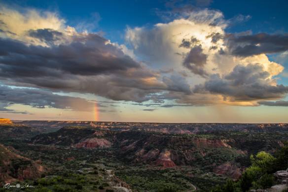
Palo Duro Canyon, exhibit A in Texas Panhandle natural beauty, as captured here complete with a rainbow by Open Skies Photography’s Richard Douglass. It is the second-longest canyon in the United States behind the Grand Canyon and one of several located in the so-called “land of the inverted mountains,” labeled as such because the area is relatively flat until you reach the long and steep canyons, highlighted by Palo Duro and Caprock Canyons to the south. (Credit: Richard Douglass.)

I really didn’t grasp until college that the area we affectionately referred to as West Texas growing up wasn’t truly West Texas, despite the fact that it was home to the institution formerly known as West Texas State University (present-day West Texas A&M University) and that our New Mexico state champion 16-and-under Amateur Athletic Union (AAU) basketball team was the Wes-Tex Sandies. To this day, West Texas is the one area of the state that I haven’t explored, and a such, it remains at the top on my short list.

Until that day, however, I have a dream and the luxury of vicarious living through pictures, from those regularly posted on McDonald Observatory’s Facebook page to the following beauts captured by fellow Aggie Glen Vigus.

I first met Glen during a past professional life in the Texas A&M College of Architecture — mine in communications and his in the now-world-famous Viz Lab, which he’s been a member of since 1998. Like so many others in the Texas A&M Department of Visualization, Glen is incredibly talented and perpetually perched on the cutting edge, from his print and digital photography to his educational efforts and insight that I would describe as a delightful mix of “how-to meets follow-me!” Although I don’t get to see him in-person much anymore, I’m routinely privy to his artistry and creativity through Facebook. So are you, thanks to his generosity of spirit in agreeing to share his Terlingua Ranch album and the related backstory for the Texas A&M Science blog.

Not unlike a Jerry Jeff Walker song, I told Glen that I think it offers the perfect blend of geography, geology and earth science with sides of astronomy and atmospheric sciences thrown in for the good educational measure that’s so important during the summer months.

I’ll let Glen take it from here — both the words and the wordless. On that latter front, like any good storyteller, I think he saved the best for last.

* ~ * ~ * ~ * ~ *

“Years ago, my dad purchased land on the Terlingua Ranch. I never knew why he was so excited about this place until I saw it. Early one morning (4 a.m.), I accompanied my dad, brother-in-law and nephew on a 10-hour drive to Terlingua. The main purpose of our journey was to survey and mark my dad’s property. It is a different world in this part of Texas. It’s isolation and natural beauty are something to behold. I’m looking forward to the next visit … I just wish it wasn’t so far away.”

Check out Day 2 of Glen’s waltz across West Texas: Big Bend National Park.

Marking Time

Ever wonder what mathematicians do on vacation? In Texas A&M professor Wolfgang Bangerth’s case, he kicked off summer 2015 by hiking through history related to another of his disciplinary specialties: geophysics.

A widely respected expert in computational mathematics and mathematical modeling, Bangerth is the author of the software program ASPECT (Advanced Solver for Problems in Earth’s Convection). His code is helping geodynamics researchers around the world visualize the Earth’s interior and related processes, thanks to funding assistance from a major facility in California at the epicenter of geodynamics research.

Earlier today, Bangerth found himself at the site of one of the worst geological disasters in U.S. history, Mount St. Helens in Washington State. Roughly one month after the 35th anniversary of the historic eruption, Bangerth toured the area, posting these incredible photographs on Facebook and agreeing to share them via the Texas A&M Science blog.

“What a treat,” Bangerth writes, “A seven-hour hike through the devastation area and then halfway up Mount St. Helens. (Additional treat: Total number of people encountered in the first six hours: 1. In fact that equals the total number of mammals encountered during this time.)”

In addition to the photos and captions, Bangerth — ever the educator — offered to expound on the science as follows:

“So here’s the story: Mount St. Helens is one of the chain of Cascade volcanos along the U.S. West Coast that exist because the Pacific (or, more exactly, the Juan De Fuca plate) subducts beneath the North American plate. They take with them millions of years of sediments, entrapped water, etc., and this leads to melting of material when they get to certain depths, and this melt then comes up a couple of 100 miles inland of the subduction zone.

“In 1980, magma rising up bulged out the side of the volcano. After an earthquake, this whole bulge collapsed in a gigantic landslide. Liberated of the pressure of the overlying rock, two enormous explosions then ripped apart most of the mountain within seconds of the landslide. There is a fantastic video of this created from a sequence of 10 or 15 pictures and also another series here.

“What you see in my pictures are the remains of the volcano (1,300 feet shorter than it was before, with its enormous gash on one side) and the valley below the landslide and miles downstream from there — in some places up to 700 feet of debris, ash and the results of several later pyroclastic flows. The deep incisions are streams that have eroded this loose material.

“The landscape is largely barren since it had, of course, not a single living organism left after the 1980 event, and is only slowly re-growing. Along the streams there are man-high trees these days, but elsewhere you only find bare gravel and sand — some covered by hardy mosses and lichens — and in many places lots of miniature bluebonnets and some Indian paintbrushes. There are ants and a few insects, but generally few vertebrates. I did see a small number of birds, including a pair of hummingbirds. By and large, it’s a huge contrast from the densely forested areas around the mountain (and how it looked before the event, as seen in older pictures).”

Daydream Believer

“Daydreaming is a short-term detachment from one’s immediate surroundings, during which a person’s contact with reality is blurred and partially substituted by a visionary fantasy, especially one of happy, pleasant thoughts, hopes or ambitions, imagined as coming to pass, and experienced while awake…”

No better day than Sunday to share this visionary fantasy — an absolutely spectacular time lapse called “The Mountain,” shot in 2011 at Spain’s El Teide, the country’s highest point and home to Teide Observatory.

Happy detaching!

Seasonal Natures

Reports earlier this week of the first snowfall in parts of Colorado came bundled for me with a somewhat jolting reminder of something I have thus far left undone. (Yep, I can almost hear my mother, if not my co-workers, laughing.) Funny how Mother Nature has a pesky way of doing that to all mammals, hibernating and otherwise.

In tribute to summer’s last gasp and stockpiling memories to last you all winter, I come bearing humble gifts — additional photographs from Texas A&M Center for Mathematics and Science Education research scientist Dr. Carolyn Schroeder and the 2014 edition of G-Camp, an outreach program for teachers offered through the Department of Geology and Geophysics in the College of Geosciences at Texas A&M University. Because Carolyn truly outdid herself in the way of great photos, I had decided back in July to reserve all floral-related ones for a special album I would post at a later date in order to showcase the more geoscience-specific ones in the previous blog entry. Seems like I blinked and it became September, but hopefully, the better late than never adage applies.

As Carolyn says, the mountain wildflowers (in this case, seen in places ranging from Silver and Yankee Boy Basins near Ouray to the ghost town of Animas Forks northeast of Silverton) were nothing short of stupendous — “everything from mountain bluebells and columbines to different colors of paintbrush, violets, delphiniums, stonecrop, pink elephants and etc. They painted the landscape in broad swaths of color. It is amazing that such loveliness can spring from such a hostile environment, even from just rubble.”

For those who might not want take a tourist’s (albeit a scientist’s) word for it, resident Colorado author Kathy Lynn Harris confirms Carolyn’s scientific analysis in a recent blog entry of her own. To borrow from Kathy’s fantastically picturesque words, “It’s been an especially good wildflower season. Even as September approaches, there are still carpets of white, yellow and lavender mountain daises and large swaths of bright purple fireweed. The sweet scent of pink and violet clover fills the air on our walks.”

I can almost smell the heaven! But enough of my procrastinating — go enjoy your own vicarious walk already, courtesy of another successful collaboration between Mother Nature and science.

Earth to Teachers

As one of the rotating images within its website header teases, what has 72 feet, covers 3,000 miles in 16 days, can earn 3 graduate hours of credit, and is more fun than summer vacation when you were a kid?

The answer is G-Camp, an outreach program for teachers offered through the Department of Geology and Geophysics in the College of Geosciences at Texas A&M University. As the ultimate in immersive summer extravaganzas, the two-week camp sets off for a variety of sites across Texas, New Mexico and Colorado, teaching the principles of geology in the field by allowing participants to explore and experience first-hand the processes and environments of planet Earth from past to present.

Texas A&M Center for Mathematics and Science Education research scientist Dr. Carolyn Schroeder serves as one of G-Camp’s instructors. Prior to coming to Texas A&M, she taught earth science in Texas public schools for 30 years, earning Texas Earth Science Teacher of the Year honors in 1986. This past year, she returned to the classroom, teaching introductory geology courses at Texas A&M in addition to her duties with CMSE, which include serving as director of the Texas A&M-College Station Regional Collaborative for Science.

Our G-Camp tour guide, Carolyn Schroeder, pictured here at Otto's Point, Colorado.

Our G-Camp tour guide, Carolyn Schroeder, pictured here at Otto’s Point, Colorado.

“Once you have taken a field trip with a geologist, you are hooked for life,” Carolyn says. “That’s what happened to me on my first one with Dr. Mel Schroeder back in 1974, and I continue to love learning about geology and sharing that love with others, both through the classes and workshops that I teach and by informal means as well.”

Consider this your two-part vicarious pictorial education, courtesy of Carolyn and G-Camp 2014! While you’re waiting for Part 2, feel free to stop and smell/see the flowers Carolyn experienced along the way and/or follow the group on Facebook for bonus pictures and information, if not points.

Core Competency

As I have mentioned in past blog entries, one of the many perks of my job is having experts at my fingertips. With a simple email, phone call or Facebook message, I can get instant feedback concerning the day’s top headlines, scientific and beyond.

Take for instance last week’s reports celebrating discovery of oceans of water beneath the Earth’s surface. I happened to catch a radio snippet recapping the Huffington Post’s version of the story as I was heading solo to the grocery store on a rare Friday vacation day. (Yeah, I’m as surprised as you are as to what qualifies as vacation for this full-time working mom of three ages 10 and under. But that’s another story with neither experts nor answers!) Intrigued, I first Googled the story to find out where it originated (Northwestern University), then emailed my friend Wolfgang Bangerth, a Texas A&M mathematician and author of a modeling software program, ASPECT, that is designed to develop, among so many other things, clearer pictures of Earth’s interior.

Besides being a computational scientist and modeling genius, Wolfgang is no slouch when it comes to geophysics — or any engineering-related branch of science, in my experience. While I knew this would be right up his alley, I didn’t realize he was in South Korea at the time teaching a weeklong workshop. Distance certainly didn’t affect his ability to advise nor my efforts to produce a press release on the subject with his copious help.

(Here’s an example of Wolfgang’s ASPECT-driven work — convection in a 3D box. Reminds me of those cool optical illusion-type puzzles you got as a kid or the nifty gel-based paperweights you sometimes see in science-types offices!)

For me, curiosity is right up there with a sense of humor and vocabulary prowess in the way of appealing attributes, but I do so love it when others share my enthusiasm for a spur-of-the-moment idea, PR-related and otherwise. Wolfgang certainly went the extra mile (pun intended) to bring this one to fruition, paying me and other communicators what I consider to be the ultimate compliment during a side discussion concerning my use of the formal “Dr.” title with him out of habitual respect:

“It’s a title. I got it by doing my job, not by being particularly brilliant. As for respect, you are doing a fantastic job, too, and I do respect that just as much. At a university, we’re a team. You can’t do your job without us, and we can’t do it without people like you. I see no reason why we shouldn’t treat each other as equals.”

Well said as always, my wise friend. Let the record show (at least in this piece) that I’m recovering nicely.

Thank you, Wolfgang, for the global assist and the team affirmation. Awesome to the core!

Another bonus of being friends with such world traveler as Wolfgang Bangerth is lots of vicarious adventures, given his love of all things outdoors, nature and related photography. Here are but three picturesque examples: traversing rugged terrain in South Korea’s Seorak Mountains National Park, exploring evolution and iterations of blue at Isla San Cristobal, Galapagos and admiring the jaw-dropping descent and beauty of Victoria Falls, Zambia, South Africa. (Credit: Wolfgang Bangerth)

Another bonus of being friends with such a world traveler as Wolfgang Bangerth is lots of vicarious adventures, given his love of all things outdoors, nature and related photography. Here are but three picturesque examples: traversing rugged terrain in South Korea’s Seorak Mountains National Park, exploring evolution and iterations of blue at Isla San Cristobal, Galapagos and admiring the jaw-dropping descent and beauty of Victoria Falls, Zambia, South Africa. (Credit: Wolfgang Bangerth)